Atlases of the 16th to 18th Century
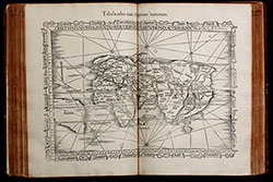
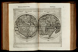
- Title Claudii Ptolemaei Alexandrini Geographicae Enarrationis, Libri Octo ... Prostant Lugduni apud Hugonem a Porta. M. D. XLI.
- Author Ptolemaeus, Claudius; Fries, Laurent; Servetus, Michael
- Year 1541
- Publisher Trechsel, Gaspar; Vienne, Dauphine; sold by Hughes de la Porte in Lyon
- Size Folio, 40.5 x 29.0 cm
Renaissance atlas with woodcut maps, based on the so-called first modern atlas of Martin Waldseemüller. For the first time, a significant number of maps with the latest geographical surveys and observations are added to the traditional Ptolemy maps. The traditional maps can be found in early manuscripts and from 1477 onwards also in printed versions of the Geographia by Claudius Ptolemy, based on written records from the years around 150 AC. Read more →
- Title Geographiae Claudii Ptolemaei Alexandrini, Philosophi ac Mathematici praestantissimi, Libri VIII...
- Author Ptolemaeus, Claudius; Münster, Sebastian; Wolffhart, Konrad; Pirckheimer, Willibald
- Year 1552
- Publisher Petri, Henrich; Basel
- Size Large 4to, 32.0 x 23.5 cm
Sebastian Münster's Geographia Universalis, printed in Basel by Henrich Petri in 1552. With 54 double page woodcut maps.
This is the 4th edition of Münster's Geographia, enhanced with a treatise by Konrad Wolffhart (Conradus Lycosthenus) and an elaborate index divided into two parts, referring now to the ancient and the modern maps. It is the last edition of the Geographia published during Münster's lifetime and the first with a royal privilege from the king of France. Read more →
- Title La Geografia di Claudio Tolomeo Alessandrino, Nuovamente tradotta di Greco in Italiano da Ieronimo Ruscelli.
- Author Ruscelli, Girolamo
- Year 1564
- Publisher Giordano Ziletti, Venice
- Size 4to, 24.5 x 17.5 cm
Third edition of Ruscelli's translation of Ptolemy's Geografia and first edition published by G. Ziletti in 1564. The first two Ruscelli editions have been published 1561 and 1562 by V. Valgrisi. The maps of the first five editions of Ruscelli are printed from the same copper plates of Valgrisi. They are based on the maps of Jacopo Gastaldi which appeared in Mattioli's 1548 translation of Ptolemy's Geographia. Read more →
![Parergon, sive Veteris Geographiae aliquot Tabulae. [Bound with:] Nomenclator Ptolemaicus.](/images/atlases/topimages/250px/1595_ortelius_parergon.jpg)
- Title Parergon, sive Veteris Geographiae aliquot Tabulae. [Bound with:] Nomenclator Ptolemaicus.
- Author Ortelius, Abraham
- Year 1595
- Publisher Christopher, Plantin; Antwerp
- Size Folio, 44.3 x 28.5 cm
An atlas of the ancient world by Abraham Ortelius. The Parergon maps began appearing as supplements within Ortelius main work the Theatrum Orbis Terrarum in 1579 with 3 maps. During the following years, more map were completed and the Parergon became an atlas in its own right. The present edition of 1595 is usually bound with the 1595 Latin edition of the Theatrum Orbis Terrarum. Read more →
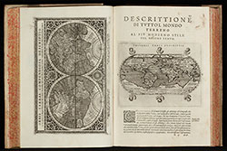
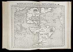
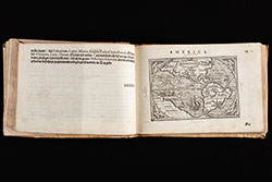
- Title Geografia cioe Descrittione Universale della Terra ... Nuovamente ... Rincontrati, & Corretti ... Gio. Ant. Magini ... Opera ... Tradotta dal R.D. Leonardo Cernoti ...
- Author Magini, Giovanni Antonio; Cernoti, Leonardo
- Year 1597
- Publisher Giovanni Battista Galignani and Giorgio Galignani, Venice
- Size 4to, 30.5 x 22.0 cm
The first edition of Leonardo Cernoti's Italian translation of Ptolemy's Geografia based on the 1596 Latin edition of Magini published by G. B. Galignani & G. Galignani in 1597-98. The maps are attributed to Girolamo Porro and have been also used in Magini's translation of 1596.
Illustrated with two engraved title vignettes, one full page and 63 half page engraved maps and several woodcuts in the text. Read more →
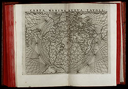
- Title Geografia di Claudio Tolomeo Alessandrino Tradotta di Greco nell'Idioma Volgare Italiano da Girolamo Ruscelli
- Author Ruscelli, Girolamo; Rosaccio, Giuseppe
- Year 1598
- Publisher M. Sessa Heirs, Venice
- Size 4to, 25.0 x 18.5 cm
Sixth edition of Ruscelli's translation of Ptolemy's Geografia edited and extended by Giuseppe Rosaccio published by the heirs of M. Sessa in 1598 and 1599.
Illustrated with 69 double page engraved maps and several woodcuts in the text. Whereof 27 Ptolemy maps and 42 'modern' map, including 4 world maps (one Ptolemy /Shirley 133, three modern /Shirley 110, 111, 217), 7 maps of America (Western Hemisphere, South America, Mexico with Florida, Brazil, east coast of North America, Haiti, Cuba), 28 European maps (including the North-Atlantic map with parts of Labrador), 10 maps of Africa and 20 maps of Asia. Read more →
- Title Ausszug auss des Abrahami Ortelij Theatro Orbis teutsch beschriben durch Levinum Hulsium, Francfort am Main. M.DC.IIII
- Author Ortelius, Abraham; Hulsius, Levinus; van Keerbergen, Jan
- Year 1604
- Publisher Levinus Hulsius, Johannes Keerbergen; Frankfurt
- Size Oblong 8to, 13.5 x 18.5 cm
Rare German edition of Ortelius's Epitome. The only published edition of Ortelius's pocket atlas with German text. This is a co-production of Levinus Hulsius and Jan van Keerbergen, printed 1604 in Frankfurt.
With engraved title page, on verso the coat of arms of Joachim Ernst of Brandenburg-Ansbach, Margrave of the Franconian Principality of Ansbach. Read more →
- Title Theatri Orbis Terrarum Parergon; Sive Veteris Geographiae Tabulae, Commentarijs Geographicis et Historicis illustratae... Balthasaris Moreti. Antverpiae, ex officina Plantiniana, M.DC.XXIV
- Author Ortelius, Abraham; Moretus, Balthasar; Llwyd, Humphrey
- Year 1624
- Publisher Balthasar Moretus, Ex Officina Plantiniana, Antwerp
- Size Imperial Folio, 47.5 x 31.0 cm
The final and most comprehensive edition of the Parergon, Ortelius's atlas of ancient Geography. The Parergon maps began appearing as supplements within Ortelius main work the Theatrum Orbis Terrarum in 1579 with 3 maps. Over the time, the map collection became an atlas in its own right. The Parergon was published mainly as appendix of the Theatrum, but also a few times separately. Read more →
- Title Sevende Stuck der Aerdrycks-Beschryving, Welck Vervat Italien en Griecken.
- Author Blaeu, Joan
- Year 1664
- Publisher Joan Blaeu, Amsterdam
- Size Imperial Folio, 57.0 x 38.5 mm
Joan Blaeu's Atlas Maior is one of the most elaborate works in the history of cartography. When completed in 1665, it was the largest and most expensive book published in the 17th century. The size and ambition of this work were beyond any scope with 594 maps in eleven volumes. It is considered so important that it was included in the Canon of Dutch History. Read more →
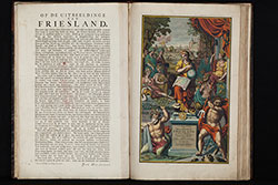
- Title Uitbeelding der heerlijkheit Friesland; zoo in 't algemeen, als in haare XXX bijzondere grietenijen; door Dr. Bern. Schotanus a Sterringa... Uitgegeeven door Francois Halma, 1718.
- Author Schotanus van Sterringa, Bernhard; Halma, François; Alting, Menso; de Broen, Gerrit; Hilarides, Johannes;
- Year 1718
- Publisher François Halma, Leeuwarden
- Size Imperial Folio, 57.0 x 37.5 cm
Second and enlarged edition of the first atlas of the Dutch province of Friesland, including 30 detail maps of the entire provinces of Friesland, an overview map of Friesland and 8 historical maps of the Netherlands.
The first edition was produced by Bernard Schotanus in 1698 after he received an order from the Gedeputeerde Staten for a new mapping out of the Grietenijen. Read more →
- Title Atlas Novus Terrarum Orbis Imperia, Regna et Status exactis Tabulis Geographice demonstrans / Novus Atlas c. tabularum, cosmo-geographicarum Homannianarum.
- Author Homann, Johann Baptist; Homann, Johann Christoph; Homann Heirs
- Year 1731
- Publisher Homann Heirs, Nürnberg
- Size Imperial Folio, 56.5 x 37.0 cm
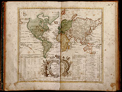
Monumental atlas of the world with 100 maps by Johann Baptist Homann. All maps coloured by an 18th-century hand.
Germany's most famous 18th-century world atlas by J. B. Homann, the founder of the famous Nuremberg map publishing house. Homann's Grosser Atlas was first published in 1716. When Homann died in 1724, the business was continued by his son Johann Christoph. Read more →
- Title Atlas Silesiae Id Est Ducatus Silesiae Generaliter Quatuor Mappis Nec Non Specialiter XVI Mappis Tot Principatus Repraesentantibus Geographice Exhibitus
- Author Homann, Johann Baptist; Homann Heirs
- Year 1750
- Publisher Homann Heirs, Nürnberg
- Size Imperial Folio, 64.0 x 48.0 cm
Large special atlas of Silesia by the Homann publishing house.
During the reign of Charles VI., the engineer Johann Wolfgang Wieland was assigned to surveying Silesia. After his death in 1736, Homann heirs in Nuremberg have been commissioned with the publication of the most detailed maps of Silesia at the time.
The atlas consists of 4 overview map with engraved text in margin and 16 large scale detailed maps with decorative cartouches. Read more →
![Ch'onha chido [Atlas of all under Heaven]](/images/atlases/topimages/250px/1750_korea.jpg)
- Title Ch'onha chido [Atlas of all under Heaven]
- Author Anonymous
- Year 1750 (mid 18th century)
- Publisher
- Size 43.5 x 41.0 cm
9 woodblock maps from a traditional Korean woodblock atlas, printed mid 18th century. Mounted in a double concertina format during the 1970s by a very skillful Korean bookbinder. Covered with Korean fabric.
Ch’onha chido (Atlas of the world) is a traditional Korean atlas produced between mid 18th and early 19th century. With a map of China and Korea and 8 maps of the provinces of Korea. Read more →
- Title Atlas geographicus omnes orbis terrarum regiones in XLI tabulis ... / Atlas géographique représentant en XLI cartes toutes les regions de la terre ...
- Author Euler, Leonhard
- Year 1753
- Publisher Michaelis, Berlin
- Size large 4to, 35.5 x 23.0 cm
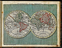
First edition of the rare atlas by Leonhard Euler. The atlas was created under the auspices of the Royal Prussian Academy of Sciences in Berlin by the famous mathematician Leonhard Euler, intended for use in schools. As such, only very few copies have survived, especially in excellent conditions. The second edition was published in 1760 with 44 maps, followed by the third unaltered edition in 1777, which was printed until 1784. Read more →
- Title Geographischer Atlas bestehend in 44 Land-Charten, worauf alle Theile des Erd-Creyses vorgestellet werden. Auf Befehl der Königlichen Academie der Wissenschaften nach den bischer herausgekommenen besten Charten beschrieben, und insbesondere zum Gebrauch der Jugend in den Schulen herausgegeben.
- Author Euler, Leonhard
- Year 1760
- Publisher Christian Ludewig Kunst, Berlin
- Size large 4to, 37.0 x 24.0 cm
Rare school atlas by the famous mathematican Leonhard Euler. It was the most successful project of the Royal Academy of Sciences in Berlin. First edition was published in 1753, titled Atlas geographicus omnes orbis terrarum regiones in XLI tabulis with a preamble of L. Euler. This second edition was published 1760, followed by third unchanged edition in 1777 until 1784. Read more →
- Title Atlas Geographicus portatilis XXIX mappis orbis habitabilis regna exhibens ... Kurzgefasste Geographie, in sich haltend einen aneinander hangenden Entwurf aller Theile des bewohnten Erdbodens, nebst compendieusen Land-Charten, welche einen kleinen Sack-Atlas ausmachen.
- Author Lotter, Tobias Conrad
- Year 1762
- Publisher Tobias Lobeck; Joh. Michael Wagner, Augsburg
- Size Oblong small 8vo, 11.5 x 14.5 cm
Pocket atlas of Tobias Conrad Lotter. Bound with "Kurzgefasste Geographie" of Tobias Lobeck. With an engraved allegorical title-page and frontispiece by Tobias Lobeck after G. Eichler, 1 world map, 1 celestial map, 37 european maps including 14 maps of Germany not mentioned in index. All fine engraved with original hand-colour. Read more →
![Ch'onha chido [Atlas of all under Heaven]](/images/atlases/topimages/250px/1780_korea.jpg)
- Title Ch'onha chido [Atlas of all under Heaven]
- Author Anonymous
- Year 1780 (late 18th century)
- Publisher
- Size 41.5 x 40.5 cm
12 manuscript maps from a traditional Korean manuscript atlas from the late 18th century. Mounted in a double concertina format during the 1970s by a very skillful Korean bookbinder. Covered with Korean fabric.
Ch’onha chido (Atlas of the world) is a traditional Korean atlas produced between mid 18th and early 19th century. With a China-centered world map (Chonha-Do), a map of China with Korea, two maps of the Ryukyu Islands and 8 maps of the Korean provinces. Read more →
- Title Atlas Saxonicus novus, enthaltend die sieben Kreise des Kuhrfürstenthums Sachsen.
- Author Schenk, Pieter; Zürner, Adam Friedrich
- Year 1781
- Publisher P. Schenk & Sohn; Amsterdam, Leipzig, Dresden
- Size Large Folio, 55.0 x 36.5 cm
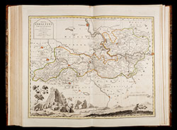
The Atlas Saxonicus novus (New Saxony Atlas), also known as the Schenkscher Atlas, is an important central German atlas from the 18th century.
After the death of the geographer Adam Friedrich Zürner in 1742, some of the maps of the Electorate of Saxony drawn by him were corrected by the geographer Paul Trenckmann and his son Johann Paul Trenckmann. Read more →
![Ch'onha chido [Atlas of all under Heaven]](/images/atlases/topimages/250px/1820_korea.jpg)
- Title Ch'onha chido [Atlas of all under Heaven]
- Author Anonymous
- Year 1820 (early 19th century)
- Publisher
- Size 44.2 x 48.0 cm
11 manuscript maps from a traditional Korean manuscript atlas from the early 19th century. Mounted in a double concertina format during the 1970s by a very skillful Korean bookbinder. Covered with Korean fabric.
Ch’onha chido (Atlas of the world) is a traditional Korean atlas produced between mid 18th and early 19th century. With a China-centered world map (Chonha-Do), a map of Korea, 7 maps of the Korean provinces, a map of China and a map of Japan. Read more →
- Title Stieler's Schul-Atlas über alle Theile der Erde nach dem neuesten Zustande, und über das Weltgebäude. Nach Stieler's Hand-Atlas verkleinert. Zwanzigste verbesserte und vermehrte Auflage.
- Author Stieler, Adolf; Reichard, Gottlieb; Bär, Johann Christoph
- Year 1840
- Publisher Justus Perthes, Gotha
- Size Large oblong 8to, 24.5 x 32.5 cm
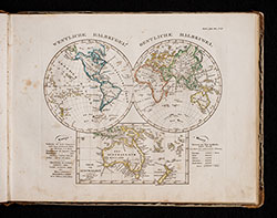
In the middle of 1817 under the direction of Wilhelm Perthes (1793-1853), the first delivery of the Hand-Atlas über alle Theile der Erde, nach dem neuesten Zustande, und über das Weltgebäude, nebst einem geogr. Texte took place. After three further deliveries, 50 maps were available in March 1823, which were later referred to as the "Original edition". Read more →